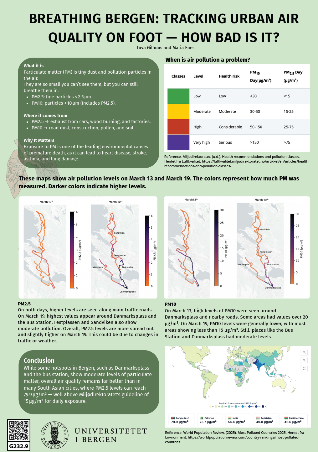
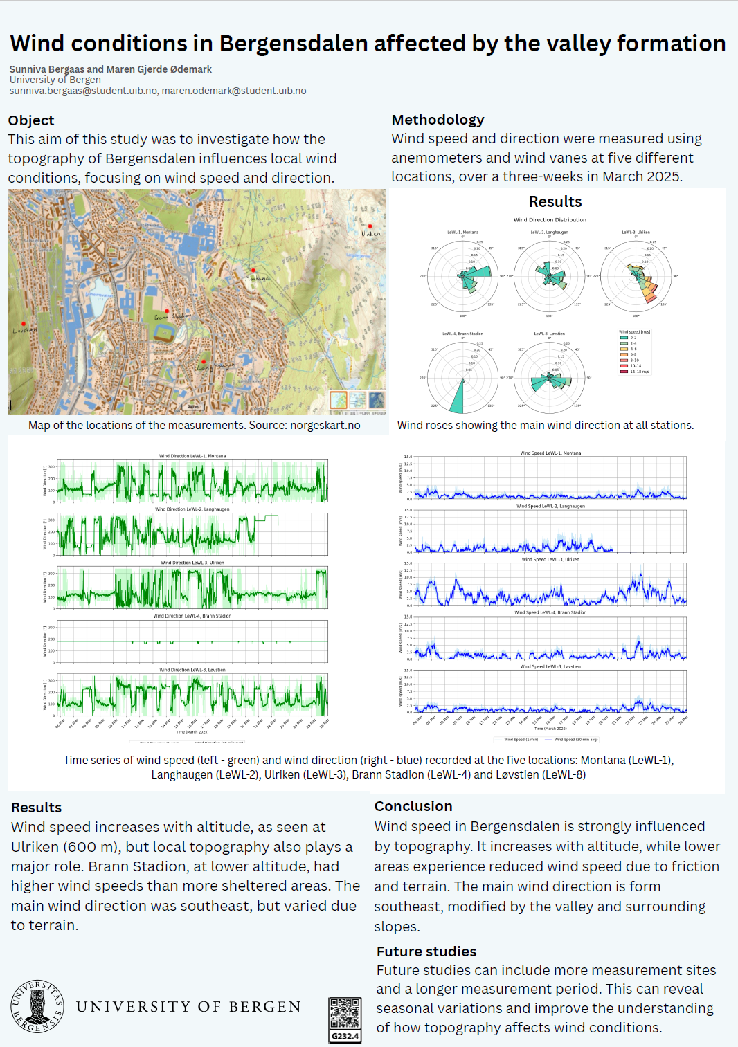
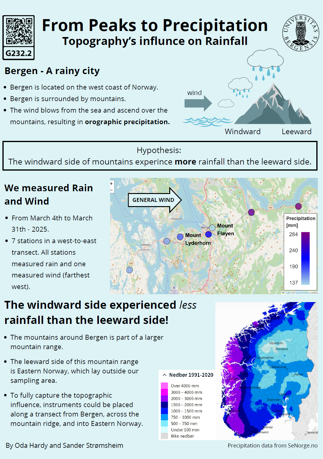
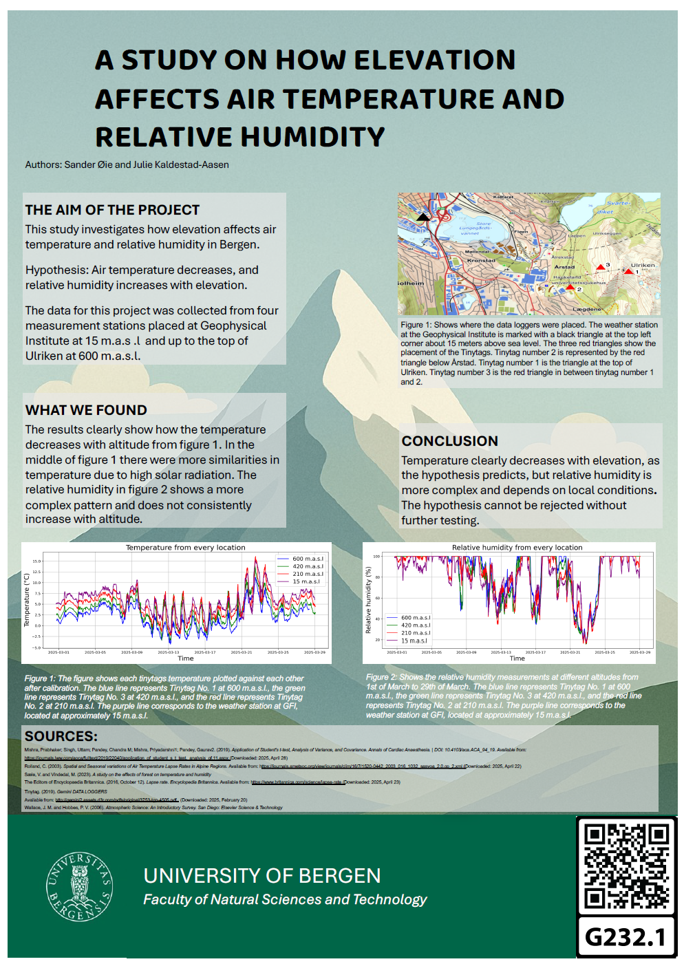
Breathing Bergen: Tracking Urban Air Quality on Foot — How Bad Is It?

Abstract

Particulate matter pollution remains an invisible but serious threat to urban health, particularly in cities influenced by heavy traffic, wood burning, and restrictive topography. This project maps air quality across Bergen’s city center using portable sensors, aiming to identify hidden pollution hotspots and understand contributing factors. Findings show that while central areas such as Festplassen, the bus station, and Danmarksplass exhibit higher particulate concentrations during stable weather conditions, Bergen’s overall air quality remains relatively low compared to, for example, Oslo, and significantly better than cities in regions like South Asia. These results highlight the importance of localized, real-world air quality measurements to support healthier and more sustainable urban environments.

Poster number:

G232.9

Authors:

Tuva Gilhuus
& Maria Enes

GEOF232 - Spring 2025

Assessment of Wind Speed and Direction in Bergen’s Urban Environment

Abstract

This study examines variations in wind speed and direction across different urban environments in Bergen, focusing on how the city’s structure influences local wind patterns. Data were collected through short-term field measurements at 28 locations in March 2025 and grouped into three categories: coastal, wind tunnel, and urban sheltered. To account for atmospheric variability, all measurements were compared to hourly reference data from the Bergen-Florida weather station, and relative wind speeds were calculated. The results show that coastal and wind tunnel locations experienced higher relative wind speeds than urban sheltered areas. A t-test confirmed a statistically significant difference between coastal and urban sheltered environments. These findings support the hypothesis that exposure and channeling effects increase wind speed in certain environments. The study highlights the importance of localized wind assessments in identifying sites with potential for smallscale wind energy in urban areas.

Poster number:

G232.8

Authors:

Evelina Eidseter
& Silje Welander

GEOF232 - Spring 2025

A comparison of wind speed and direction in different topographical locations up Ulriken

Abstract

This study aims to analyze how varying topographies along Ulriken in Bergen affect wind speed and direction. Three locations, from the bottom to the top of the mountain, were selected to represent different topographical conditions; ranging from areas with minimal terrain friction to those near buildings and trees, which reduce exposure and increase friction. Wind data was collected over three weeks using anemometers provided by GFI-Bergen. The results indicate significant variations in wind speed and direction, with higher and more consistent winds recorded at the top, and slower, more turbulent winds near the bottom of the mountain.

Poster number:

G232.7

Authors:

Henrik Bjørheim
& Johan Cotta Wallerud

GEOF232 - Spring 2025

Temperature variation in Bergen

Abstract

The purpose of this study was to determine whether temperature varies across different districts of Bergen, and if so, to what extent and due to which factors. Many cities in Europe struggle with the accumulation of trapped heat resulting from vehicular traffic and human activity; consequently, temperatures may differ within a city and cause damage to infrastructure. To facilitate this study, a manual measurement approach was employed in the form of surveys. A total of four surveys were conducted across areas characterized as dense, wide, green, and exposed to vehicular traffic, with varying levels of sunlight exposure.

These surveys provided a clear picture of temperature tendencies in specific locations and demonstrated that temperature variations are not constant but may depend on several factors, such as the overall ambient temperature. In these surveys, the recorded maximum temperature variations ranged from 2.1°C to 3.0°C, although most fluctuations in temperature trends did not exceed 0.5°C. Regardless of whether the general temperature trend was positive or negative, small variations were observed whenever a location transitioned from shaded to sunlit conditions or vice versa. In one instance, moving from a dense urban area to a wide, green area with significant tree coverage resulted in a temperature decrease of approximately 1.0°C.

The study's quantitative, descriptive approach shows that temperature variations within Bergen are moderate, and that the main contributing factors to these variations are exposure to sunlight, street width, and the amount of vegetation present in an area.

Poster number:

G232.6

Authors:

Mateusz Zydek

GEOF232 - Spring 2025

The Impact of Fjord Sill Size on Oxygen Depletion

Abstract

Fjord basins are increasingly at risk of climate-induced deoxygenation. The cyclical processes within fjords can take decades, creating stagnant, oxygendepleted masses of water. Studies reveal Norwegian fjords are particularly vulnerable to decreased oxygen-rich intrusions due to the warming of North Atlantic Waters (NAW) by 1 °C (Aksnes, 2019). Defined as the shallow seafloor of a fjord inlet, sills drive circulatory processes. Circulation over the sill is accredited as the primary driver of oxygenation in Norwegian fjords (Johnsen, 2024). This study investigates the effect of sill sizes through standardized CTD measurements: dissolved oxygen, temperature, depth, salinity, photosynthetically available radiation, and chlorophyll. Of the six fjords analyzed, the four with a single inlet provided evidence indicating larger sills decreased circulation in the fjord basins, thereby increasing deoxygenation. Low oxygen levels, (=< 4 mg/L) occurred at higher depths behind shallower sills, further exemplified by a graph and trendline; R^2 = 0.8936. Many ecological issues arise at least in part due to oxygen loss, such as algal blooms, decreased biodiversity, and habitat stratification. Further research could explore how freshwater intrusion and anthropogenic solutions could alleviate these stressors.

Poster number:

G232.5

Authors:

Robert H. Reinsvold

GEOF232 - Spring 2025

Wind conditions in Bergensdalen affected by the valley formation

Abstract

This study analyzes how the topography of Bergensdalen, a U-shaped valley in Bergen, influences local wind conditions over a three-week period in March 2025. Wind speed and direction were measured using anemometers and wind vanes placed at five different locations. The data were then visualized using wind roses and graphs. The results show clear differences in wind conditions at different locations, due to the influence by the surrounding mountains. The main findings shows that wind speed increases with higher altitudes, while at lower altitudes the wind speed reduces due to topographical effects and friction. The main wind direction was from the southwest, although it was partly blocked by the mountains.

Poster number:

G232.4

Authors:

Sunniva Bergaas
& Maren Ødemark

GEOF232 - Spring 2025

Salinity and Temperature Variability Related to Wind Variability in Store Lungegårdsvann, Bergen

Abstract

Our project investigates the link between wind variability and variations in salinity and temperature in Store Lungegårdsvann, a bay connected to the Puddefjorden at Bergen. Over a three-week period, data were collected using CTD Seabird SBE37, SBE56 sensors, and a HOBO MX2302A for air temperature and humidity. Meteorological data, such as wind speed and direction, were retrieved from external sources. The study focuses on a four-day period, from March 6 to 10 2025, during which significant fluctuations in salinity and temperature were noted. The results indicate a significant correlation between salinity and water temperature, suggesting that wind-induced mixing plays an important role in fjord dynamics. Wind direction has an impact on salinity, with onshore winds increasing salinity and offshore winds decreasing it. The transition from stable to unstable periods is explained by a significant change in air and water temperature, leading to mixing in the water column. This study highlights the importance of integrating wind measurements when analyzing surface variability in fjord environments.

Poster number:

G232.3

Authors:

Sarah Hartmann
& Louise Ferraris

GEOF232 - Spring 2025

From Peaks to Precipitation: Topography’s influence on rainfall

Abstract

Orographic precipitation, driven by the forced ascent of moist air over mountainous terrain, plays a major role in shaping regional climates. Bergen, Norway, located between the North Sea to the west and steep mountains to the east, is known for its consistently high rainfall.

In this study, we investigated how the mountainous terrain surrounding Bergen modulates rainfall intensity and distribution. Precipitation measurements were collected along a west-to-east transect from Sotra to Trengereid, using seven HOBO rain gauges. Wind measurements were conducted at Sotra using a Wind logger, to monitor wind directions during the study period.

Our cumulative results identified two distinct rainy periods, from March 5–10 and March 23–30, 2025. Analysis indicated a clear precipitation gradient, with rainfall increasing by approximately 73% from the west coast inland toward Trengereid. During these events, prevailing winds were predominantly southerly to south-easterly.

The results show the connection between the moist air from the sea being forced over the mountainous terrain and the precipitation levels in the area. These results not only help explain Bergen’s famously wet climate, but also provide insights into broader patterns affecting coastal mountainous regions worldwide.

Poster number:

G232.2

Authors:

Oda Kristina Krogh Hardy
& Sander Strømsheim

GEOF232 - Spring 2025

A study on how elevation affects air temperature and relative humidity

Abstract

This study investigates the effects of elevation on air temperature and relative humidity in Bergen, Norway. The primary hypothesis is that temperature decreases and relative humidity increases with altitude, in accordance with the atmospheric lapse rate. Data was collected between February 28 and March 29, 2025, using three Tinytag loggers and an Automatic Weather Station positioned at four elevations ranging from 15 to 600 meters above sea level. The collected data included temperature, relative humidity and dew point. Linear regression and a statistical test were used to analyze the data. The results show a clear decrease in temperature with increasing elevation, supporting the lapse rate theory. The trend in relative humidity was less consistent, and the results did not support the hypothesis. However statistical analysis suggests that the observed variations are likely due to random factors rather than a true effect of elevation. This means the hypothesis cannot be dismissed without further testing. Local topography and environmental factors, such as vegetation and terrain, are identified as possible influences on the data. Overall, the study confirms a negative correlation between temperature and elevation, while the relative humidity is more complicated. This research provides valuable insights into vertical atmospheric gradients, contributing to a better understanding of how local environmental factors affect temperature and humidity profiles.

Poster number:

G232.1

Authors:

Julie Kaldestad-Aasen
& Sander Øie

GEOF232 - Spring 2025