Iceberg shapes and melt processes

Abstract

Icebergs are chunks of ice, which break off from marine terminating glaciers. They mostly stem from the Greenlandic and Antarctic Ice Sheets but can also be found in other areas in polar regions. They are a crucial feature of our oceans, since some major shipping tracks cross paths of larger icebergs. This poster looks at the shapes of icebergs and melt processes depending on the properties of the surrounding water.

In general icebergs have different shapes and can be separated into tabular (like a flat sheet) and non-tabular (other types of structures) icebergs. They also come in different sizes, with the smallest being 5 m tall and 15 m wide and the largest being 3900 km2, which is larger than the Spanish island of Mallorca. The icebergs melt due to multiple processes. These are surface melting due to solar radiation and wind, wave erosion on the side, convective melting at the submarine sides and basal melting at the bottom. These processes create different freshwater plumes depending on the background flow strength.

screenshot of the poster entitled Iceberg shapes and melt processes

Poster number:

G338.7

GEOF338 - Spring 2025

Ice Factories of the South: Antarctic Coastal Polynyas and Deep Water Formation

Abstract

Coastal polynyas are persistent open-water areas surrounded by sea ice, predominantly found along the Antarctic coast. These polynyas form primarily due to strong offshore katabatic winds that continuously remove newly formed sea ice, exposing ocean water to extremely cold atmospheric conditions. Such rapid and continuous ice formation leads to significant brine rejection, a process where salt is expelled from freezing seawater, increasing the salinity and density of the water below. This denser water mass is termed Dense Shelf Water (DSW) and sinks (cascades) down the continental slope, directly contributing to the formation of Antarctic Bottom Water (AABW). AABW is the densest and coldest water mass circulating in the global ocean. Using the Weddell Sea as a key example, this poster explores the essential role of Antarctic coastal polynyas as critical ice-production sites and their significant impact on deep ocean circulation.


screenshot of the poster entitled Ice Factories of the South:
Coastal Polynyas and Deep Water
Formation in the Antarctic

Poster number:

G338.6

GEOF338 - Spring 2025

Mind the Gap – Understanding Arctic Sea-Ice Leads

Abstract

Arctic sea-ice leads, gaps in the sea-ice cover, serve as critical windows for energy and mass exchange between the ocean and atmosphere. While typically small in area, these openings dominate wintertime heat fluxes and influence cloud formation, new ice growth, and seasonal melt patterns. This poster presents a summary of recent research on the formation, climatic impact, satellite detection, and model representation of Arctic sea-ice leads.

Field and satellite observations show that turbulent heat fluxes over leads can be up to 100 times greater than over adjacent sea ice. Lead activity varies regionally and seasonally and plays a measurable role in sea-ice dynamics. By accounting for the intensified energy exchange through leads, climate models achieve better agreement with observed Arctic surface temperatures and ice thickness patterns. Increased lead formation in winter and spring is strongly associated with increased summer sea-ice loss, underscoring the role of leads in seasonal Arctic ice dynamics. As global warming drives Arctic sea-ice retreat and thinning, accurately detecting and representing leads remains essential for understanding polar feedback mechanisms and forecasting Arctic climate evolution.


screenshot of the poster entitled MIND THE GAP
Understanding Sea-ice Leads

Poster number:

G338.5

GEOF338 - Spring 2025

Large-Scale Temperature Estimates in Fram Strait using Ocean Acoustics

Abstract

Fram Strait, located between Svalbard and Greenland, is dominated by two major currents: The West Spitsbergen Current brings saline and warm Atlantic water northwards, and the East Greenland Current brings fresh and cold Arctic water southwards. These mesoscale variabilities in temperature and salinity cause significant fluctuations within the water layers in Fram Strait. It is challenging to measure salinity and temperature in this area because of the presence of sea ice and depth-range limitations of in-situ measurements, making it challenging to create accurate ocean models.

This poster shows how ocean acoustics can be used to improve temperature estimates. The sound speed of acoustic waves, which can travel hundreds of kilometers, depends on temperature and salinity. The propagation and travel times of acoustic rays can be computed using ray tracing. The travel times of these acoustic waves can then be processed to provide large-scale temperature maps. Acoustic data from two experiments has been processed and is presented showing temperature maps in Fram Strait over distances of hundreds of kilometers. The first experiment shows that temperature errors are about 20moC. In the second experiment data assimilation was used to integrate the temperature measurements into a regional ocean circulation model, giving improved ocean temperature estimates. This shows that acoustic data can be used to improve temperature estimates in ocean models and thereby contribute to a better understanding of climate changes in Fram Strait.


screenshot of the poster entitled Large-Scale Temperature Estimates in Fram Strait Using Ocean Acoustics

Poster number:

G338.4

GEOF338 - Spring 2025

Measuring Nitrate in the Arctic Ocean with the Submersible Ultraviolet Nitrate Analyzer (SUNA)

Abstract

The Arctic Ocean, though the smallest of the world’s oceans, plays a crucial role in regulating global ecosystems and biogeochemical cycles through its currents and water masses. Nitrogen is the key element responsible for limiting phytoplankton growth and annual primary production in the Arctic Ocean. Climate-induced reductions in sea ice extent and volume are altering the growth conditions for marine phytoplankton, with consequences for the Arctic marine ecosystem.

Obtaining high quality data in this region is challenging and autonomous instruments have become essential tools for long-term and continuous monitoring. The Submersible Ultraviolet Nitrate Analyser (SUNA) can measure chemical-free nitrate in fresh, brackish and salt water and is based on In-Situ Ultraviolet Spectroscopy. However, in natural waters, the conditions for SUNA to measure nitrate can be challenging, reducing its accuracy and precision. Nevertheless, with post-processing algorithms and routines it is possible to obtain high quality datasets. SUNA nitrate measurements can thus contribute to the understanding of future changes in the Arctic Ocean and their global implications.

screenshot of the poster entitled Measuring Nitrate in the Arctic Ocean with the Submersible
Ultraviolet Nitrate Analyzer (SUNA)

Poster number:

G338.3

Authors:

Lilli Weninger

GEOF338 - Spring 2025

The changing Greenland Sea – from convection to stratification

Abstract

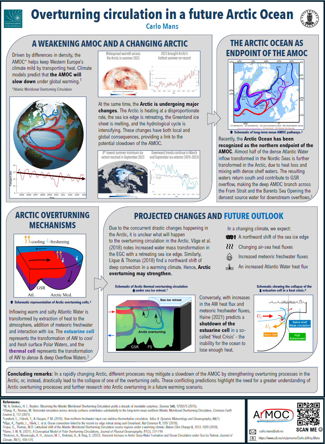
The Greenland Sea has undergone a fundamental transformation over the past several decades - from a major site of deep-water formation to a stratified basin with more shallow convection. Historically, wintertime convection in the region, driven by brine rejection during sea-ice formation, enabled dense surface waters to sink and drive vertical deep ocean mixing. This process plays a key role in supporting the lower branch of the Atlantic Meridional Overturning Circulation (AMOC).

However, recent research on the Greenland Sea reveals a marked decline in deep convection over time. Increasing freshwater input from sea-ice melt and Arctic outflow has enhanced upper-ocean stratification, reducing surface density and limiting vertical mixing. This has shifted the stratification from a haline-controlled (β-ocean) to thermally controlled (α-ocean), with a clear shift identified around 1998. Since then, only intermediate water formation has been observed, and the thermobaric mechanism for deep convection has been effectively shut down. This shift has large consequences. Reduced formation of dense water in the Greenland Sea could weaken the lower branch of the AMOC, with potential impacts on global heat distribution, carbon uptake, and regional climate. The future evolution of the Greenland Sea—and feedbacks from changes in sea ice cover, freshwater fluxes, and atmospheric forcing—will be crucial in determining whether deep convection can resume or whether stratification will intensify and further weaken the AMOC.

Screenshot of the poster entitled The changing Greenland sea –From convection to stratification

Poster number:

G338.2

GEOF338 - Spring 2025

Atlantification of the Arctic Ocean: A Rapid Transformation of the Marine Ecosystem

Abstract

The Arctic is currently undergoing fundamental changes that are gradually dissolving its unique polar character. Significant features of global climate change in recent decades are the main reasons for sea-ice decline and the warming of the Arctic atmosphere and ocean. These changes have far-reaching climatological consequences. A central process of this upheaval is the so-called "Atlantification", characterized by the increasing inflow of warmer and saltier Atlantic Water (AW). Atlantification manifests physically as a weakening of the cold halocline layer and a shoaling (upward shift) of the AW layer, enhancing vertical mixing and the upward heat flux from the AW to the surface. This enhanced oceanic heat release has become a major contributor to the observed rapid loss of sea ice in the eastern Eurasian Basin.

The resulting reduction in winter sea ice formation is significant but this ongoing physical reorganization also drives profound ecological changes, often referred to as Borealization. Boreal species such as Atlantic cod, capelin, and herring are expanding northward, while Arctic species like polar cod are declining. The loss of sea ice habitat also impacts associated organisms, and a related shoaling of the nutricline increases nutrient availability in the upper ocean with possible consequences for primary production. Atlantification thus represents an essential step towards a new Arctic climate state with major implications for both physical climate feedbacks and the marine ecosystem structure.

screenshot of the poster entitled Atlantification of the Arctic: A Rapid Transformation of Ocean and Ecosystem

Poster number:

G338.1

GEOF338 - Spring 2025

Consequences of Arctic Sea Ice Loss in Recent Decades

Abstract

Recent rapid sea-ice reduction in the Arctic Ocean (AO) has been well documented in model simulations, observations, and reconstructions. The decline in Arctic sea ice in recent decades has been attributed, in large part, to increasing greenhouse warming and we are expected to observe an ice-free summer in upcoming decades. As a result of the above trends in observed Arctic sea ice, it is important to understand the consequences of Arctic sea ice loss for both local and global climate patterns and marine ecosystems. To understand these consequences, we present a review of recent studies that investigate the implications of Arctic sea ice loss. We will in particular focus on sea ice decline in the Barents Sea (20-60°E, 67.5-85°N). Changes to Atlantic Water inflow in this region play a significant role in determining sea ice cover. Through the case study on the Barents Sea, we conclude that the main consequences of Arctic sea ice loss in recent decades include; disturbance of global weather patterns, a threat to coastal communities, and extreme temperatures. We also demonstrate how a decline in sea ice in the AO, will drive further Arctic warming and sea ice loss due to Arctic Amplification. The above consequences provide a rationale for continued monitoring of Arctic sea ice.

Poster number:

338_11

Authors:

Marianne Williams-Kerslake

GEOF338 - Spring 2024

Prospects of overturning in a future Arctic Ocean

Abstract

The Atlantic Meridional Overturning Circulation (AMOC) is projected to experience a slowdown due to anthropogenic global warming. Concurrently, the Arctic Ocean is undergoing rapid transformations, including retreating sea ice extent, changing freshwater inputs from rivers and melting ice and increased Atlantic Water (AW) heat transport and air-sea heat fluxes. Following the realization that not only the Nordic Seas, but also the Arctic Ocean is a major component in sustaining the AMOC, the Arctic Ocean has emerged as a region of particular interest for further research. In the Arctic Ocean, the transformation of AW yields two key products, related to distinct overturning circulation branches: dense overflow waters, contributing to the thermal overturning branch, and Polar Waters (PW) created by mixing with freshwater from sources like rivers and melting ice, forming the estuarine circulation branch. Here we will discuss an outlook for the Arctic Ocean overturning in a future climate, as well as some of the processes involved in potentially counterbalancing AMOC decline. For instance, recent research contrastingly highlights the potential for a northward shift of deep convection areas, strengthening Arctic overturning, and the potential for the collapse of one of its overturning cells.

Poster number:

338_10

Authors:

Carlo J. Mans

GEOF338 - Spring 2024

The circulation of the Nordic Seas: from surface to depth

Abstract

The general surface circulation of the Nordic Seas consists of poleward flowing relatively warm waters from the Atlantic and a return flow along the East Greenland Current with colder and fresher waters, along with transformed Atlantic waters sub-surface. The mid-depth circulation of the Nordic Seas, particularly the exchange between the various basins, however, has not been well studied, but is important for understanding the main pathways between dense water formation regions towards the overflows of the Greenland Scotland Ridge. The transformation of the water to denser and colder waters is important for dense water overflowing towards the North Atlantic and supplying the lower limb of the AMOC. Here we use Argo floats drifting at intermediate depths (1000 – 1500 m) to provide an overview of this mid-depth circulation. We found the highest velocities along the boundaries and in the Norwegian Sea along steep topography, while the velocities in the interior basins are lower. Floats generally remain within the basin they were deployed in unless they are entrained into the boundary current. This occurs primarily when the interior gyre circulation is close to the boundary, or where steep topography can cause instabilities. The exchanges across submarine ridges show certain preferred inter-basin pathways, except for the crossings between the Greenland and Lofoten Seas. This circulation shows similar features to the surface boundary current, but interior pathways are distinctly different and reveal the main pathways connecting the basins.

Poster number:

338_9

Authors:

Erika Giorgi

GEOF338 - Spring 2024