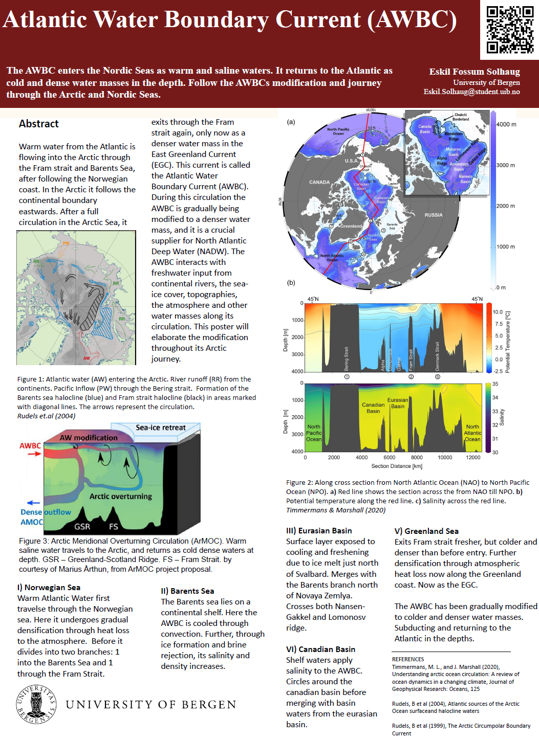
Iceberg shapes and melt processes

Abstract

Icebergs are chunks of ice, which break off from marine terminating glaciers. They mostly stem from the Greenlandic and Antarctic Ice Sheets but can also be found in other areas in polar regions. They are a crucial feature of our oceans, since some major shipping tracks cross paths of larger icebergs. This poster looks at the shapes of icebergs and melt processes depending on the properties of the surrounding water.

In general icebergs have different shapes and can be separated into tabular (like a flat sheet) and non-tabular (other types of structures) icebergs. They also come in different sizes, with the smallest being 5 m tall and 15 m wide and the largest being 3900 km2, which is larger than the Spanish island of Mallorca. The icebergs melt due to multiple processes. These are surface melting due to solar radiation and wind, wave erosion on the side, convective melting at the submarine sides and basal melting at the bottom. These processes create different freshwater plumes depending on the background flow strength.

Poster number:

G338.7

GEOF338 - Spring 2025

Ice Factories of the South: Antarctic Coastal Polynyas and Deep Water Formation

Abstract

Coastal polynyas are persistent open-water areas surrounded by sea ice, predominantly found along the Antarctic coast. These polynyas form primarily due to strong offshore katabatic winds that continuously remove newly formed sea ice, exposing ocean water to extremely cold atmospheric conditions. Such rapid and continuous ice formation leads to significant brine rejection, a process where salt is expelled from freezing seawater, increasing the salinity and density of the water below. This denser water mass is termed Dense Shelf Water (DSW) and sinks (cascades) down the continental slope, directly contributing to the formation of Antarctic Bottom Water (AABW). AABW is the densest and coldest water mass circulating in the global ocean. Using the Weddell Sea as a key example, this poster explores the essential role of Antarctic coastal polynyas as critical ice-production sites and their significant impact on deep ocean circulation.


Poster number:

G338.6

GEOF338 - Spring 2025

Mind the Gap – Understanding Arctic Sea-Ice Leads

Abstract

Arctic sea-ice leads, gaps in the sea-ice cover, serve as critical windows for energy and mass exchange between the ocean and atmosphere. While typically small in area, these openings dominate wintertime heat fluxes and influence cloud formation, new ice growth, and seasonal melt patterns. This poster presents a summary of recent research on the formation, climatic impact, satellite detection, and model representation of Arctic sea-ice leads.

Field and satellite observations show that turbulent heat fluxes over leads can be up to 100 times greater than over adjacent sea ice. Lead activity varies regionally and seasonally and plays a measurable role in sea-ice dynamics. By accounting for the intensified energy exchange through leads, climate models achieve better agreement with observed Arctic surface temperatures and ice thickness patterns. Increased lead formation in winter and spring is strongly associated with increased summer sea-ice loss, underscoring the role of leads in seasonal Arctic ice dynamics. As global warming drives Arctic sea-ice retreat and thinning, accurately detecting and representing leads remains essential for understanding polar feedback mechanisms and forecasting Arctic climate evolution.


Poster number:

G338.5

GEOF338 - Spring 2025

Large-Scale Temperature Estimates in Fram Strait using Ocean Acoustics

Abstract

Fram Strait, located between Svalbard and Greenland, is dominated by two major currents: The West Spitsbergen Current brings saline and warm Atlantic water northwards, and the East Greenland Current brings fresh and cold Arctic water southwards. These mesoscale variabilities in temperature and salinity cause significant fluctuations within the water layers in Fram Strait. It is challenging to measure salinity and temperature in this area because of the presence of sea ice and depth-range limitations of in-situ measurements, making it challenging to create accurate ocean models.

This poster shows how ocean acoustics can be used to improve temperature estimates. The sound speed of acoustic waves, which can travel hundreds of kilometers, depends on temperature and salinity. The propagation and travel times of acoustic rays can be computed using ray tracing. The travel times of these acoustic waves can then be processed to provide large-scale temperature maps. Acoustic data from two experiments has been processed and is presented showing temperature maps in Fram Strait over distances of hundreds of kilometers. The first experiment shows that temperature errors are about 20moC. In the second experiment data assimilation was used to integrate the temperature measurements into a regional ocean circulation model, giving improved ocean temperature estimates. This shows that acoustic data can be used to improve temperature estimates in ocean models and thereby contribute to a better understanding of climate changes in Fram Strait.


Poster number:

G338.4

GEOF338 - Spring 2025

Measuring nitrate in the Arctic Ocean

Abstract

The Arctic Ocean, though the smallest of the world’s oceans, plays a crucial role in regulating global ecosystems and biogeochemical cycles through its currents and water masses. Nitrogen is the key element responsible for limiting phytoplankton growth and annual primary production in the Arctic Ocean. Climate-induced reductions in sea ice extent and volume are altering the growth conditions for marine phytoplankton, with consequences for the Arctic marine ecosystem.

Obtaining high quality data in this region is challenging and autonomous instruments have become essential tools for long-term and continuous monitoring. The Submersible Ultraviolet Nitrate Analyser (SUNA) can measure chemical-free nitrate in fresh, brackish and salt water and is based on In-Situ Ultraviolet Spectroscopy. However, in natural waters, the conditions for SUNA to measure nitrate can be challenging, reducing its accuracy and precision. Nevertheless, with post-processing algorithms and routines it is possible to obtain high quality datasets. SUNA nitrate measurements can thus contribute to the understanding of future changes in the Arctic Ocean and their global implications.

Poster number:

G338.3

Authors:

Lilli Weninger

GEOF338 - Spring 2025

The changing Greenland Sea – from convection to stratification

Abstract

The Greenland Sea has undergone a fundamental transformation over the past several decades - from a major site of deep-water formation to a stratified basin with more shallow convection. Historically, wintertime convection in the region, driven by brine rejection during sea-ice formation, enabled dense surface waters to sink and drive vertical deep ocean mixing. This process plays a key role in supporting the lower branch of the Atlantic Meridional Overturning Circulation (AMOC).

However, recent research on the Greenland Sea reveals a marked decline in deep convection over time. Increasing freshwater input from sea-ice melt and Arctic outflow has enhanced upper-ocean stratification, reducing surface density and limiting vertical mixing. This has shifted the stratification from a haline-controlled (β-ocean) to thermally controlled (α-ocean), with a clear shift identified around 1998. Since then, only intermediate water formation has been observed, and the thermobaric mechanism for deep convection has been effectively shut down. This shift has large consequences. Reduced formation of dense water in the Greenland Sea could weaken the lower branch of the AMOC, with potential impacts on global heat distribution, carbon uptake, and regional climate. The future evolution of the Greenland Sea—and feedbacks from changes in sea ice cover, freshwater fluxes, and atmospheric forcing—will be crucial in determining whether deep convection can resume or whether stratification will intensify and further weaken the AMOC.

Poster number:

G338.2

GEOF338 - Spring 2025

Atlantification of the Arctic Ocean: A Rapid Transformation of the Marine Ecosystem

Abstract

The Arctic is currently undergoing fundamental changes that are gradually dissolving its unique polar character. Significant features of global climate change in recent decades are the main reasons for sea-ice decline and the warming of the Arctic atmosphere and ocean. These changes have far-reaching climatological consequences. A central process of this upheaval is the so-called "Atlantification", characterized by the increasing inflow of warmer and saltier Atlantic Water (AW). Atlantification manifests physically as a weakening of the cold halocline layer and a shoaling (upward shift) of the AW layer, enhancing vertical mixing and the upward heat flux from the AW to the surface. This enhanced oceanic heat release has become a major contributor to the observed rapid loss of sea ice in the eastern Eurasian Basin.

The resulting reduction in winter sea ice formation is significant but this ongoing physical reorganization also drives profound ecological changes, often referred to as Borealization. Boreal species such as Atlantic cod, capelin, and herring are expanding northward, while Arctic species like polar cod are declining. The loss of sea ice habitat also impacts associated organisms, and a related shoaling of the nutricline increases nutrient availability in the upper ocean with possible consequences for primary production. Atlantification thus represents an essential step towards a new Arctic climate state with major implications for both physical climate feedbacks and the marine ecosystem structure.

Poster number:

G338.1

GEOF338 - Spring 2025

Consequences of Arctic Sea Ice Loss in Recent Decades

Abstract

Recent rapid sea-ice reduction in the Arctic Ocean (AO) has been well documented in model simulations, observations, and reconstructions. The decline in Arctic sea ice in recent decades has been attributed, in large part, to increasing greenhouse warming and we are expected to observe an ice-free summer in upcoming decades. As a result of the above trends in observed Arctic sea ice, it is important to understand the consequences of Arctic sea ice loss for both local and global climate patterns and marine ecosystems. To understand these consequences, we present a review of recent studies that investigate the implications of Arctic sea ice loss. We will in particular focus on sea ice decline in the Barents Sea (20-60°E, 67.5-85°N). Changes to Atlantic Water inflow in this region play a significant role in determining sea ice cover. Through the case study on the Barents Sea, we conclude that the main consequences of Arctic sea ice loss in recent decades include; disturbance of global weather patterns, a threat to coastal communities, and extreme temperatures. We also demonstrate how a decline in sea ice in the AO, will drive further Arctic warming and sea ice loss due to Arctic Amplification. The above consequences provide a rationale for continued monitoring of Arctic sea ice.

Poster number:

338_11

Authors:

Marianne Williams-Kerslake

GEOF338 - Spring 2024

Prospects of overturning in a future Arctic Ocean

Abstract

The Atlantic Meridional Overturning Circulation (AMOC) is projected to experience a slowdown due to anthropogenic global warming. Concurrently, the Arctic Ocean is undergoing rapid transformations, including retreating sea ice extent, changing freshwater inputs from rivers and melting ice and increased Atlantic Water (AW) heat transport and air-sea heat fluxes. Following the realization that not only the Nordic Seas, but also the Arctic Ocean is a major component in sustaining the AMOC, the Arctic Ocean has emerged as a region of particular interest for further research. In the Arctic Ocean, the transformation of AW yields two key products, related to distinct overturning circulation branches: dense overflow waters, contributing to the thermal overturning branch, and Polar Waters (PW) created by mixing with freshwater from sources like rivers and melting ice, forming the estuarine circulation branch. Here we will discuss an outlook for the Arctic Ocean overturning in a future climate, as well as some of the processes involved in potentially counterbalancing AMOC decline. For instance, recent research contrastingly highlights the potential for a northward shift of deep convection areas, strengthening Arctic overturning, and the potential for the collapse of one of its overturning cells.

Poster number:

338_10

Authors:

Carlo J. Mans

GEOF338 - Spring 2024

The circulation of the Nordic Seas: from surface to depth

Abstract

The general surface circulation of the Nordic Seas consists of poleward flowing relatively warm waters from the Atlantic and a return flow along the East Greenland Current with colder and fresher waters, along with transformed Atlantic waters sub-surface. The mid-depth circulation of the Nordic Seas, particularly the exchange between the various basins, however, has not been well studied, but is important for understanding the main pathways between dense water formation regions towards the overflows of the Greenland Scotland Ridge. The transformation of the water to denser and colder waters is important for dense water overflowing towards the North Atlantic and supplying the lower limb of the AMOC. Here we use Argo floats drifting at intermediate depths (1000 – 1500 m) to provide an overview of this mid-depth circulation. We found the highest velocities along the boundaries and in the Norwegian Sea along steep topography, while the velocities in the interior basins are lower. Floats generally remain within the basin they were deployed in unless they are entrained into the boundary current. This occurs primarily when the interior gyre circulation is close to the boundary, or where steep topography can cause instabilities. The exchanges across submarine ridges show certain preferred inter-basin pathways, except for the crossings between the Greenland and Lofoten Seas. This circulation shows similar features to the surface boundary current, but interior pathways are distinctly different and reveal the main pathways connecting the basins.

Poster number:

338_9

Authors:

Erika Giorgi

GEOF338 - Spring 2024

The Atlantic Water Boundary Current (AWBC) in the Arctic

Abstract

Warm water from the Atlantic is flowing into the Arctic through the Fram strait, after following the Norwegian coast. After a full circulation in the Arctic Sea, it exits through the Fram strait again, only now as a denser water mass in the East Greenland Current (EGC). The Atlantic Current that circumnavigates in the Arctic is an extension of the Atlantic Water Boundary Current (AWBC) and flows eastwards along the northern continental slope of Eurasia and North America. During this circulation the AWBC is gradually being modified to a denser water mass. During its circulation the AWBC interacts with freshwater input from continental rivers, the sea-ice cover, different types of bathymetries, the atmosphere and other different water masses in the Arctic. Over the most recent decades a retreating sea ice cover has increased the amount of interaction between AWBC and the atmosphere, implying an increase in water modification due to heat loss to the atmosphere. This poster will elaborate the modification throughout.

Poster number:

338_8

Authors:

Eskil Fossum Solhaug

GEOF338 - Spring 2024

Antarctic Slope Current: System, Classification and Annual Variability Models

Abstract

The Antarctic Slope Current (ASC) circumnavigates the Antarctic continent following the continental slope, separating the waters on the continental shelf from the deeper offshore Southern Ocean and regulates the flow towards the Antarctic coastline. We can classify the current’s frontal structure in 3 ranges: warm shelf, fresh shelf and dense shelf. It is difficult to reveal its spatial and sub-annual variability, as direct velocity measurements are sparse. Spatial variability of the ASC has also been characterized as three flow regimes: the surface-intensified ASC, the bottom-intensified ASC, and the reversed ASC. The surface-intensified ASC regime is stronger in the winter months. Seasonality of the winds may be the relevant driver for the seasonality along stretches of the coastline with a surface-intensified ASC. The reversed ASC has an inverted seasonality, meaning it is weaker in the winter months. The surface-intensified ASC occurs at sections of the continental slope with a fresh shelf, the bottom-intensified ASC occurs at dense shelves, and the reversed ASC occurs at warm shelves. Seasonality of the ASC is influenced not only by the mechanical forcing provided by the winds and sea ice at the ocean surface, but also by a geostrophic adjustment to changes in the cross-slope density gradient via freshwater input from basal melting and via surface water mass transformation.

Poster number:

338_7

Authors:

Rosalina Ribeiro

GEOF338 - Spring 2024

Freshwater variability and transport in the East Greenland Current

Abstract

The East Greenland Current (EGC) transports fresh and cold Polar Water (PW) southwards from the central Arctic Ocean. Observations of strength and properties of the EGC have been monitored through moored instruments in Fram Strait since 1997. Freshwater transport since 2015 has decreased, with an exception for 2017. The general decrease is caused by a velocity reduction of the EGC and PW. Results points to an “Atlantification” of the western Fram Strait section. Mechanisms controlling the export of freshwater from the EGC, both in liquid and solid forms, are explored using an idealized numerical model and scaling theory. Climate models predict an increase of offshore winds and decrease in Arctic export of sea-ice for the coming future. This leads to a decrease in offshore sea-ice transport. Uncertainties occur for onshore freshwater transport, as it may both increase or decrease depending on the changing effects of Ekman transport and offshore eddy fluxes.

Poster number:

338_6

Authors:

Eirik Kvamme

GEOF338 - Spring 2024

Basal melting beneath the Fimbul Ice Shelf

Abstract

Ice shelves are thick floating platforms of ice that connect land and ocean. Since 2016, sustained warming has led to significant and increasing Antarctic basal melting - melting of the underside of ice an shelf by the ocean. The rate of basal melting is primarily influenced by the characteristics of the sub-ice shelf–ocean boundary layer, a turbulent region responsible for the exchange of heat and salt between the ocean and the ice. This turbulent layer is usually driven by convection or shear-driven processes. As ice shelves thin due to basal melting, their ability to support the ice upstream decreases, leading to an increase in the ice flow from land to sea and subsequent sea level rise. Most of the heat responsible for melting ice shelves is transported by ocean currents flowing into the cavities beneath the ice shelves. Recent observations from ApRES (Autonomous phase-sensitive Radio-Echo Sounder) at the Fimbul Ice Shelf in East Antarctica have detected a long-term mean ablation rate of up to 1.0 ± 0.4 meters per year beneath the central region of the ice shelf. Further observations from 2017 to 2021 have shown sub-weekly to monthly variations in basal melting rates attributed to shear-driven turbulent heat transfer processes along with seasonal variations driven by ocean warming during the austral summer.

Poster number:

338_5

Authors:

Mathilde Helbert

GEOF338 - Spring 2024

Different sea-ice characteristics influence on wave damping

Abstract

Due to increasing temperatures, the sea ice is thinning and weakening in the Arctic. This makes sea ice more prone to changes from atmospheric forcings such as wind and waves. In the Marginal Ice Zone (MIZ) there are many processes occurring, and one of them are waves-in-ice dynamics. Researchers are trying to implement these processes in coupled ice-ocean models, but due to large differences in types of ice and ice thickness it is hard to find a good model accounting for every physical process.
The poster will review how ice thickness and floe size influences waves when the waves are dampened by the ice. It is hard to directly measure the specific influence of ice thickness and floe size in the MIZ due to the large differences in ice characteristics over small areas, difficult access and rapid changes. Therefore most data are collected in land-fast ice, however some research has been done directly in the MIZ based upon visual estimates. It is clear that increasing ice thickness and floe size attenuate and dampen waves to a greater extent than thinner ice. This could have impacts on the Arctic ecosystems, specifically due to an increasing MIZ when the sea ice is thinner, so waves can travel further and open areas which have been closed and protected by sea ice.

Poster number:

338_4

Authors:

Kristine S. Gulla

GEOF338 - Spring 2024

Thermobaric convection: principles and some regions of interest

Abstract

The density of water depends on temperature, salinity and pressure. When sea ice forms brine rejection takes place which leads to an increase in the density of the underlying water. Depending on the ocean stratification, this can lead to convection where the denser water sinks. This type of convection is called type I convection and occurs regularly during winter in polar seas. It slowly deepens the mixed layer as the pycnocline gets eroded. However, there is also a type II convection that can only take place under specific circumstances, and which can lead to ventilation of the entire water column. This type of convection relies on thermobaricity: the effect of pressure on water’s density. Colder, fresh waters get more compressed (and thus dense) under pressure than warm, saline waters. This means that a seemingly stable ocean profile might be unstable when a water parcel reaches a depth where thermobaricity becomes important. This can then result in type II convection. However, in order to get a type II convection, the background stratification needs to be overcome. The normalised strength of thermobaricity indicates the likeliness of this to happen. Still, there is another important factor that determines whether type II convection can occur: the thermobaric barrier. This poster dives into the processes controlling thermobaricity and examines a case study over Maud Rise near Antarctica. Lastly, it provides an overview of stratification types in the World oceans.

Poster number:

338_3

Authors:

Marre Groeneboer

GEOF338 - Spring 2024

On ice retreat and convection in the Greenland sea

Abstract

Convection and deep-water formation in the Greenland Sea play crucial roles in the Atlantic Meridional Overturning Circulation (AMOC). Much of this convection occurs along the sea-ice edge, driven by strong temperature gradients between the atmosphere and the exposed ocean. This process leads to cooling of the surface layer, resulting in increased density and subsequent sinking of surface waters. As the climate changes, due to global warming, the sea-ice edge is retreating, causing a re-organization of water mass transformation. Understanding this re-organization is essential, as the AMOC significantly impacts global climate and temperatures, as well as regional climate here in Bergen. This poster investigates the relationship between sea-ice edge retreat and convection in the Greenland Sea. It highlights a significant retreat of the sea-ice edge along the east coast of Greenland over recent decades, particularly noticeable during the winter months when convection is most active. Additionally, the poster explores how the re-organization of convection could imply both a weakening or even give resilience to the AMOC. By examining these dynamics, the poster shed light on relationships between the sea-ice edge, convection, and broader implications for global climate.

Poster number:

338_2

Authors:

Marte Vrålstad
& Idunn Hana

GEOF338 - Spring 2024

Influence of polynyas on deep water formation

Abstract

Polynyas are primarily open water sea ice free areas surrounded by sea ice, formed by either strong winds or oceanic currents that drives away the sea ice. There are two types of polynyas: coastal polynyas (very thin ice present) and open water polynyas (no sea ice). For both types of polynyas, it is the direct contact between the atmosphere and the water that leads to the formation of deep water. Indeed, the water will cool much faster in polynyas thanks to the absence of sea ice or the presence of very thin sea ice, thus the water will be denser and even more so with the salinity released from the surrounding sea ice. The two main areas for deep water production are the North Atlantic (North Atlantic Deep Water (NADW)) and the Southern Ocean (Antarctic Bottom Water (AADW)).

Poster number:

338_1

Authors:

Melanie Fauchez-Le-Gouic
& Noelie Duport

GEOF338 - Spring 2024

Upper Ocean hydrographic variability on the South Orkney Plateau

Poster 338_5

Abstract

Hydrographic properties of the upper ocean on the South Orkney Plateau, Antarctica, from austral summer 2011-2020 are processed using data collected alongside krill trawlings. This shows good applicability of this method and contributes to improved hydrographic monitoring. The results show clear salinity driven stratification. The fresh and warm surface water displays a positive northward temperature gradient. Below the upper pycnocline the colder and more saline Winter Water was found. In some years indications of the Upper Circumpolar Deep Water was also found, which indicates the southern boundary of the Antarctic Circumpolar Current. On an inter-annual scale, the surface waters exhibit large variability. Years with more sea ice free days prior to sampling have warmer and more saline surface properties and vice versa. No direct link between the hydrographic properties and the Antarctic krill (Euphasia Superba) abundance and distribution was found. This is likely due to correlations with additional factors and is subject to further work.

Poster number:

338_5

GEOF338 - Spring 2023

Ocean currents and upwelling around Antarctica

Abstract

The ocean around Antarctica – the Southern Ocean, is a major player for biological production and global ocean circulation. The currents around Antarctica connect and mix the water masses of the Pacific, the Atlantic and the Indian Ocean. This is the Antarctic Circumpolar Current (ACC), a wind driven current and the strongest current in the world. The strong flow also isolate Antarctica from warm waters to the north, keeping it cool. This is an important feature for sea-ice production. The same winds that drive the ACC also drive Ekman-upwelling both a lower and an upper cell. This is critical for the overturning of deep and bottom water. Since the deeper upwelling water is nutrient rich, the Southern Ocean mixed layer is a favourable place for biology. One famous example is the Southern Ocean trap. This is a feature that traps dissolved silicon in the region, making it the habitat for many silicifiers, for example diatoms and radiolaria. Going in the opposite direction as the ACC is the slope current. This current is generated by dense sinking water masses that are deflected by the Coriolis force.

Poster number:

338_4

GEOF338 - Spring 2023